

-
Research Article
-
An Integrated Agricultural Drought Index Incorporating Event Characteristics and Lagged Responses
가뭄의 빈도·지속기간·강도와 지수 간 시차를 반영한 농업가뭄 통합지수 개발
-
Young-Sik Mun, Won-Ho Nam, Seokkyun Yu
문영식, 남원호, 유석균
- Agricultural drought arises from complex interactions among hydro-meteorological variables, making it difficult to characterize using a single drought index. This study develops …
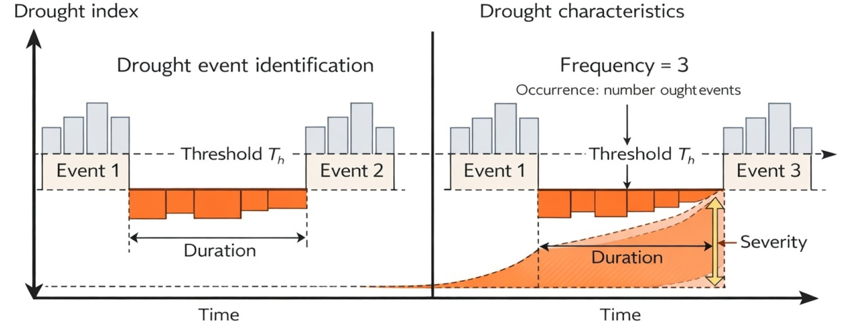
- Agricultural drought arises from complex interactions among hydro-meteorological variables, making it difficult to characterize using a single drought index. This study develops an integrated agricultural drought index (IADI) that incorporates drought event characteristics and time-lag relationships among multiple indicators. Grid-based drought indices from 1996 to 2024 were analyzed using run theory to quantify key drought characteristics, including frequency, duration, and severity, which were used to construct a composite drought severity measure. The relative importance of individual indices was estimated using entropy, CRITIC, and principal component analysis (PCA), and further refined by incorporating time-lag effects between drought indices and agricultural drought responses. The proposed IADI was applied across South Korea, revealing consistently higher drought intensity in southern regions, particularly in Jeolla and Gyeongsang provinces, as well as in parts of northern Gyeonggi and Jeju Island. Despite differences in weighting schemes, the spatial patterns of IADI were highly consistent, with over 90% of grid cells exhibiting identical drought classifications. These results demonstrate that the proposed index provides a robust and reliable representation of agricultural drought conditions. The IADI offers a practical tool for drought monitoring and spatial risk assessment and establishes a scalable framework for integrating multi-source data and lag-aware modeling in future drought prediction systems. The IADI provides a lag-aware, multi-index framework for robust agricultural drought assessment under increasing hydro-climatic variability. - COLLAPSE
-
An Integrated Agricultural Drought Index Incorporating Event Characteristics and Lagged Responses
-
Research Article
-
Classification of Flooding in Paddy Field Using Hard Attention-based Deep Learning Model
하드 어텐션 기반 딥러닝 모델을 활용한 논벼 담수 분류
-
Jaewon Sok, Kwihoon Kim, Maga Kim, Jin-Yong Choi
석재원, 김귀훈, 김마가, 최진용
- Flooding irrigation in the paddy field creates an anaerobic environment in the soil, generating methane emissions. Monitoring flooding irrigation is important to …
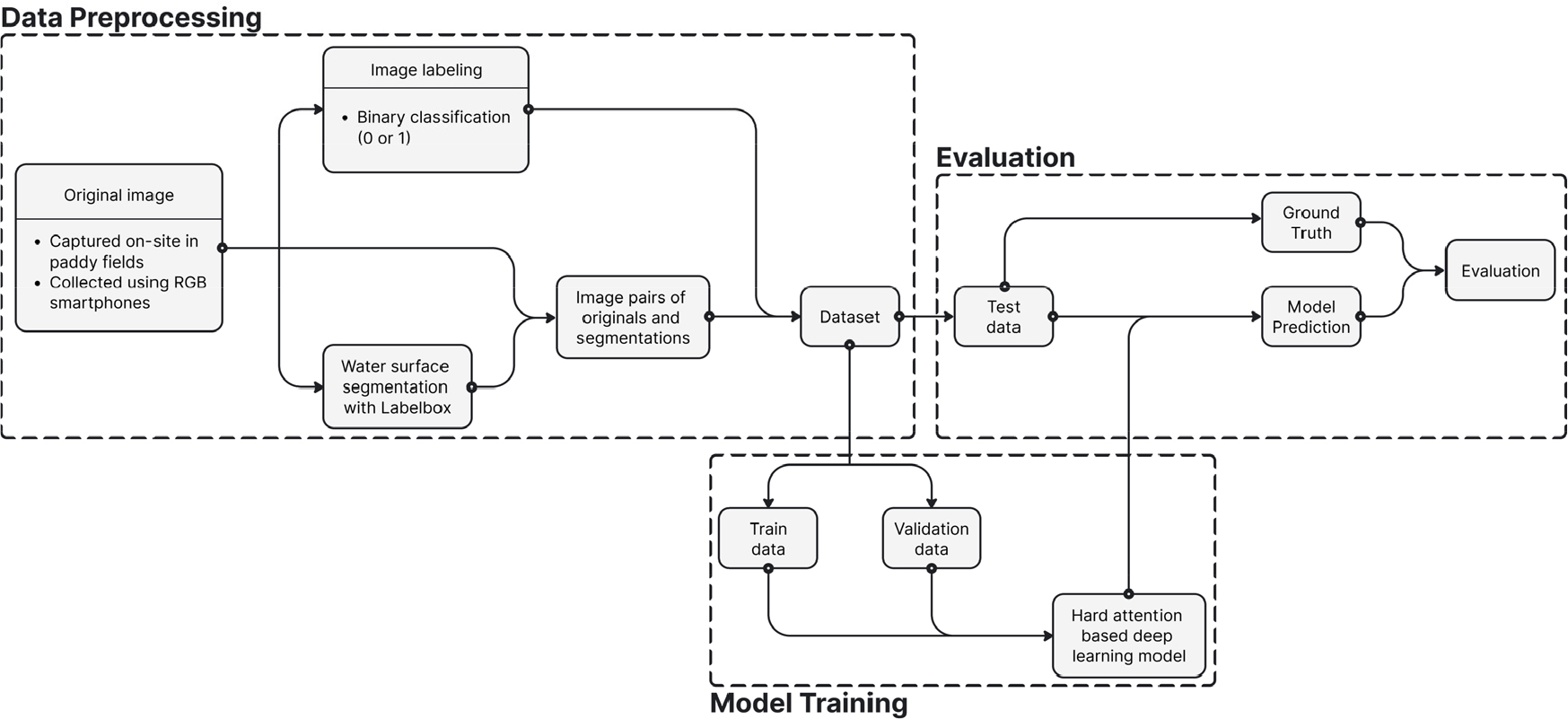
- Flooding irrigation in the paddy field creates an anaerobic environment in the soil, generating methane emissions. Monitoring flooding irrigation is important to estimate methane emission; however, monitoring flooding depth in the paddy field remains challenging due to technical limitations caused by varying environmental conditions and a lack of cost-effective measurements. This study aimed to develop a deep learning framework incorporating Hard Attention mechanisms to classify flooding or dry conditions in paddy fields. The framework combines three components: a segmentation model that identifies water regions, a base model that analyzes entire images, and a focus model that examines the segmented water surface. These components are integrated through a decision model that combines both local and global features. This study evaluated sequential training (pre-training base and focus models independently) versus simultaneous end-to-end training. The sequentially trained decision model achieved the highest performance (accuracy: 0.85, F1-score: 0.87), while the base model showed inferior results (accuracy: 0.79, F1-score: 0.81), and the focus model demonstrated intermediate performance (accuracy: 0.80, F1-score: 0.85). These findings confirm that integrating global contextual information with targeted water-region features through attention mechanisms enhances classification performance for intermittent irrigation monitoring. Future work will examine model generalizability across diverse environmental conditions. - COLLAPSE
-
Classification of Flooding in Paddy Field Using Hard Attention-based Deep Learning Model
-
Research Article
-
Application of DAMBRK-HEC-RAS Coupled Model for Simulating Sediment-Laden Flow due to Agricultural Reservoir Failure
농업용 저수지 붕괴 시 토사 흐름 모의를 위한 DAMBRK-HEC-RAS 연계 모형의 적용성 평가
-
Seongjae Park, Jihye Kwak, Jihye Kim, Sinae Kim, Jaeyoung An, Suhwan Park, Seonjae Park, Moon Seong Kang
박성재, 곽지혜, 김지혜, 김시내, 안재영, 박수환, 박선재, 강문성
- The risk of dam failure in South Korea has been significantly elevated by intensified extreme rainfall and aging earth-fill agricultural reservoirs. The …
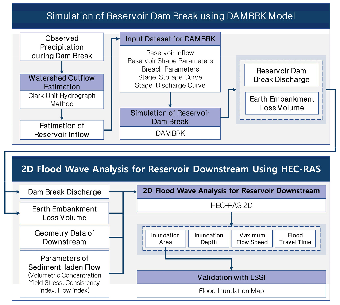
- The risk of dam failure in South Korea has been significantly elevated by intensified extreme rainfall and aging earth-fill agricultural reservoirs. The failure of an earth-fill dam releases a significant volume of embankment material into the dam-break flow, altering the rheological properties of the flood wave and causing damage through sediment burial. Therefore, dam-break flood analyses should account for non-Newtonian behavior for earth-fill dam failures. This study constructed a coupled DAMBRK–HEC-RAS (Hydrologic Engineering Center – River Analysis System) 2D framework to simulate flood waves induced by earth-fill dam failure. Breach outflow and embankment erosion were estimated by DAMBRK. The breach outflow hydrograph was used as an inflow condition for unsteady flow analysis in HEC-RAS 2D, while embankment erosion was used to support the sediment-laden flow assumption. A case study was conducted on an agricultural reservoir that experienced embankment failure due to overtopping during extreme rainfall in August 2020. Flood damage characteristics, including inundation depth, inundation extent, and flood arrival time were compared under varying rheological parameters and fluid assumptions. Compared with the Newtonian model, the non-Newtonian assumption mainly affected flood-wave attenuation after the peak and increased inundation duration. The sensitivity analysis showed that yield stress and consistency index strongly control flood-wave attenuation, while the flow behavior index has a comparatively minor effect. The proposed framework provides a practical basis for downstream flood damage prediction and supports disaster mitigation planning. - COLLAPSE
-
Application of DAMBRK-HEC-RAS Coupled Model for Simulating Sediment-Laden Flow due to Agricultural Reservoir Failure
-
Research Article
-
Correlation Analysis of Environmental and Growth Factors Affecting Pig Manure Calorific Value in Smart Livestock Housing
돈분열량 지표를 활용한 스마트축사 환경 및 생육 요인 상관성 분석 연구
-
Hyo-Jae Seo, Jin-A Park, Jin-Won Park, Il-Hwan Seo
서효재, 박진아, 박진원, 서일환
- Enhancing productivity in the livestock industry remains a critical challenge, necessitating precise management and optimization of the internal environment within livestock facilities. …
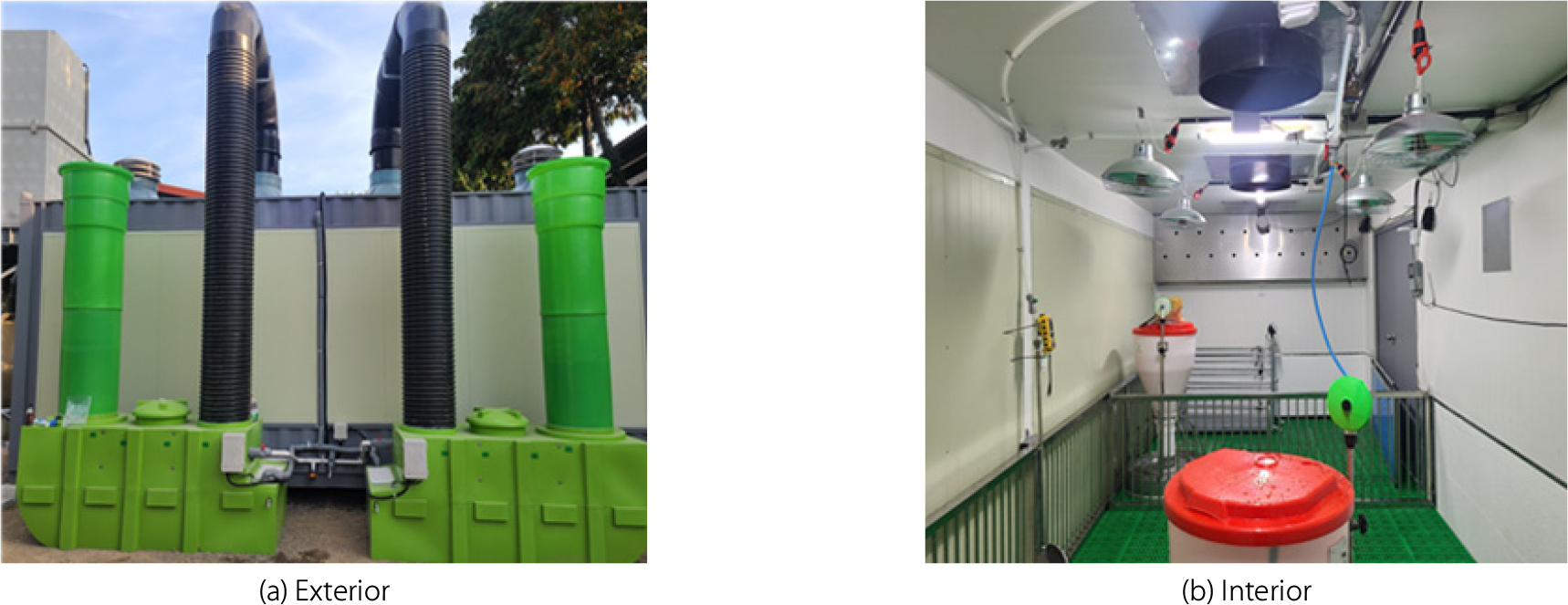
- Enhancing productivity in the livestock industry remains a critical challenge, necessitating precise management and optimization of the internal environment within livestock facilities. Effective environmental control requires the analysis of both environmental and physiological data from the animals. In this study, an experimental environmentally controlled chamber equipped with environmental and biological monitoring systems was utilized to analyze the relationships between pig body weight, feed intake, water intake, and manure calorific value, alongside environmental parameters such as temperature and humidity. Correlation analysis revealed a significant positive relationship between pig manure calorific value and body weight (r = 0.741, p < 0.01), as well as between body weight and feed intake (r = 0.647, p < 0.01). The pig manure calorific value increased approximately 5.2-fold from the weaning piglet stage (384 kcal/kg DM) to the early finishing stage (approximately 71 kg body weight; 2,000 kcal/kg DM), primarily reflecting stage-specific changes in diet composition and feed intake rather than a decline in apparent total tract digestibility with growth. Because the experiment was conducted under stable winter conditions (internal temperature: 21.9 ± 2.3°C, relative humidity: 35.3%) with limited environmental variability, no significant correlation was observed between pig manure calorific value and internal temperature (r = 0.114, p > 0.05). Therefore, in this study the pig manure calorific value is positioned primarily as an indicator for stage-specific feeding management rather than as a real-time feedback variable for environmental control. The results provide fundamental analytical data that can support stage-specific feeding strategies and energy-efficient management in smart livestock housing operations. - COLLAPSE
-
Correlation Analysis of Environmental and Growth Factors Affecting Pig Manure Calorific Value in Smart Livestock Housing
-
Research Article
-
Developing an Integrated Vulnerability Index for Agricultural Infrastructure and Water Resources using SSP Scenarios
SSP 시나리오를 활용한 농업기반시설 및 농어촌용수 통합 취약성 평가지표 개발
-
Soo-Jin Kim, Ha-young Kim, Seung-Hwan Yoo, Yeongcheol Kwak, DalJu Park, YunPyo Lee, Seung-Jong Bae
김수진, 김하영, 유승환, 곽영철, 박달주, 이윤표, 배승종
- Climate change vulnerability assessments for agricultural water resources and agricultural infrastructure began with a pilot study in 2018, and the results of …
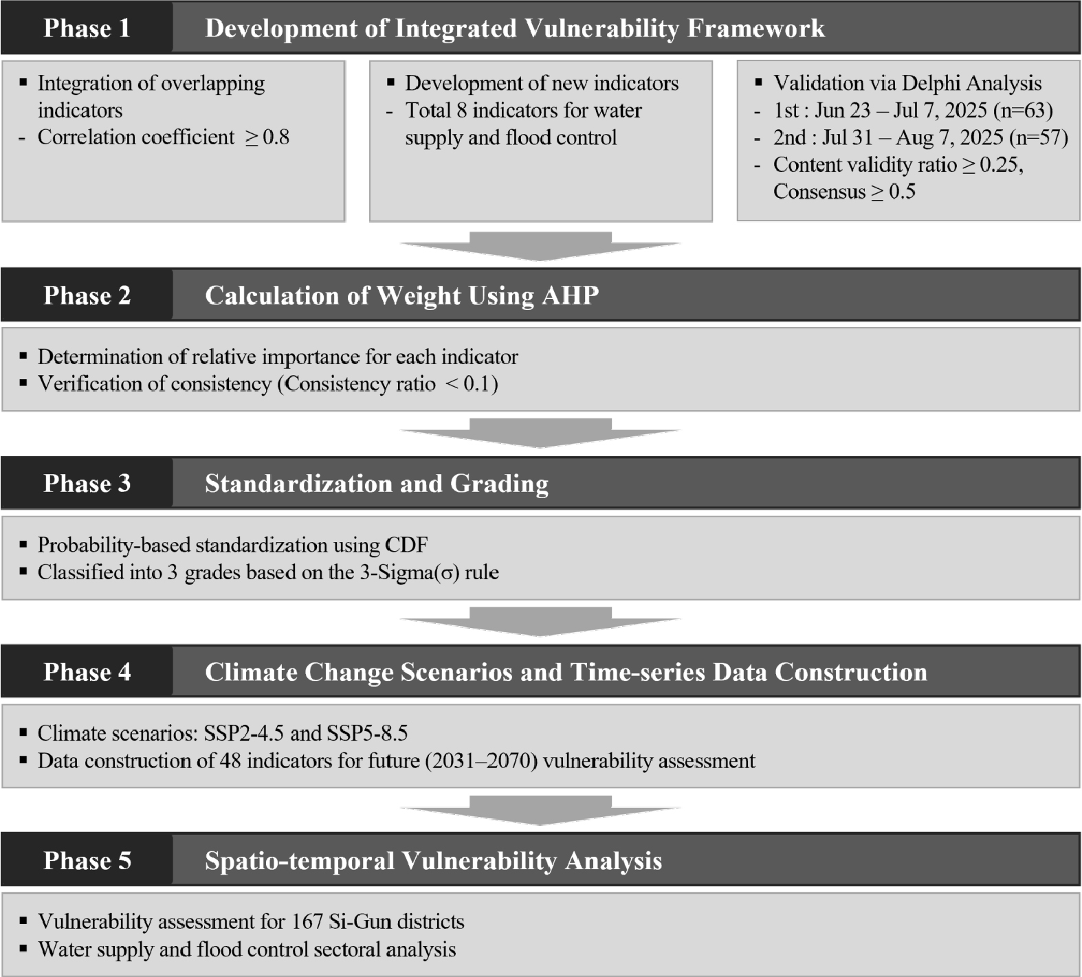
- Climate change vulnerability assessments for agricultural water resources and agricultural infrastructure began with a pilot study in 2018, and the results of the first cycle were officially published in 2023. To address the limitations identified in the first cycle, such as spatial inconsistency, indicator redundancy, and lack of expert validation, this study establishes an integrated vulnerability assessment framework by unifying the analysis unit into administrative districts (Si-Gun). Pearson correlation analysis was performed to merge indicators with a correlation coefficient of 0.8 or higher. Eight new indicators were also developed, and a total of 48 indicators were validated through a Delphi analysis. Additionally, weights were determined using the Analytic Hierarchy Process (AHP) to reflect the relative importance of each sector. Future vulnerability was analyzed for the period from 2031 to 2070 using SSP2-4.5 and SSP5-8.5 climate change scenarios across 167 Si-Gun. The results indicated high vulnerability in the water supply sector in the coastal areas of Jeonnam and inland regions of Gyeongbuk. In the flood control sector, vulnerability was intensified in the southern coastal regions and the northern border areas of Gyeonggi. Notably, southwestern Jeonnam was identified as vulnerable to both droughts and floods, highlighting the urgent need for integrated multi-disaster management strategies. This study is expected to provide critical reference data for establishing regional customized water resource management and disaster prevention strategies under shifting climate conditions. - COLLAPSE
-
Developing an Integrated Vulnerability Index for Agricultural Infrastructure and Water Resources using SSP Scenarios
-
Research Article
-
AI-Driven Estimation of Agricultural Drought Damage Using Satellite Remote Sensing
위성영상과 딥러닝 융합 기반 농업가뭄 피해 추정
-
Hyeok-Jae Choi, Won-Ho Nam, Hee-Jin Lee, Ho-Sun Lee
최혁재, 남원호, 이희진, 이호선
- Agricultural drought impacts on crop production are becoming increasingly severe under intensifying climate variability and extreme weather conditions. This study presents a …
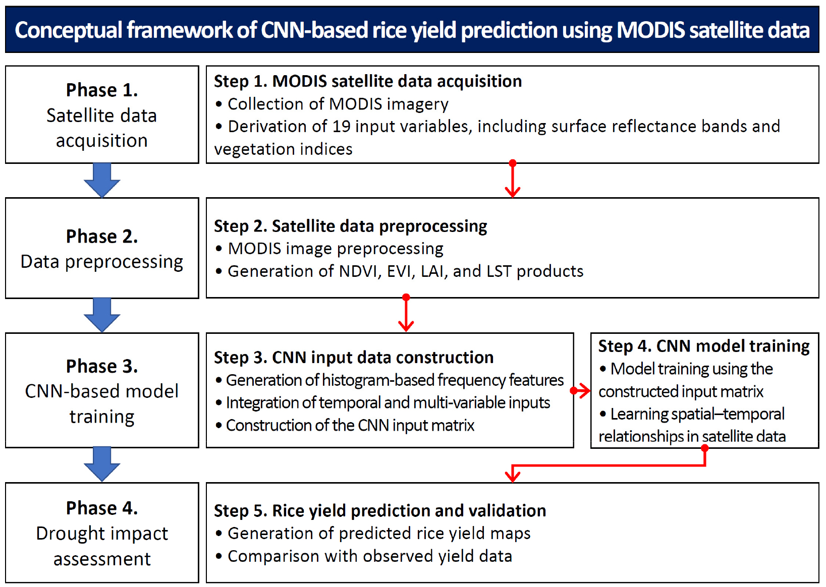
- Agricultural drought impacts on crop production are becoming increasingly severe under intensifying climate variability and extreme weather conditions. This study presents a satellite-based deep learning framework for estimating rice yield reduction as supplementary information for agricultural drought impact assessment by integrating multi-source Moderate Resolution Imaging Spectroradiometer (MODIS) observations with data-driven modeling. Nineteen variables derived from MODIS data, including vegetation indices, land surface temperature, evapotranspiration-related variables, productivity variables, and surface reflectance bands, were used to characterize crop growth and environmental conditions. A Convolutional Neural Network (CNN) model was developed to estimate municipal-scale rice yield using satellite-derived variables. Rice yield reduction was quantified using a yield anomaly (YA) approach, in which CNN-predicted rice yields were compared with long-term baseline yields. The estimated yield reduction was subsequently used as an indirect indicator to examine the spatial distribution of potential agricultural drought impacts. The results demonstrated that the integration of multi-source MODIS observations and deep learning successfully reproduced spatial variations in rice yield and provided useful supplementary information for identifying areas vulnerable to drought-related production losses. The proposed framework enables spatially explicit monitoring of rice yield reduction and supports agricultural drought impact assessment by offering timely information on potential crop damage. These findings highlight the potential of satellite remote sensing and artificial intelligence approaches to complement conventional drought monitoring systems and improve impact-based agricultural drought assessment. - COLLAPSE
-
AI-Driven Estimation of Agricultural Drought Damage Using Satellite Remote Sensing
-
Research Article
-
LCA-Based Carbon Emissions Assessment and Structural-Environmental Efficiency Evaluation of Disaster-Resilient Plastic Greenhouse Construction
내재해형 비닐 온실 건설 단계의 LCA 기반 탄소 배출량 산정 및 구조-환경 효율성 평가
-
Jongmin Choi, Younghwan Son, Sangbeom Jo, Wonyoung Lee
최종민, 손영환, 조상범, 이원영
- While life cycle assessment (LCA) of buildings is well established, the construction phase of plastic greenhouses—which dominate protected horticulture yet rely on …
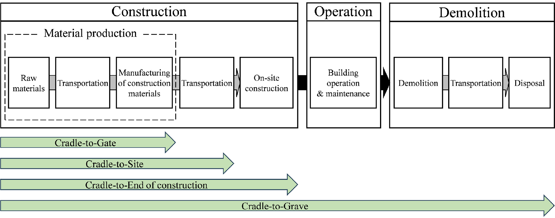
- While life cycle assessment (LCA) of buildings is well established, the construction phase of plastic greenhouses—which dominate protected horticulture yet rely on lightweight, labor-intensive assembly—has rarely been assessed. This study quantifies the construction stage carbon emissions of disaster-resilient plastic greenhouses and evaluates their structural-environmental efficiency. For 38 single-span and multi-span greenhouse types, the system boundary was set from material production to the completion of on-site construction (Cradle-to-End of construction), applying the National LCI DB and standard construction estimates. The material production stage accounted for over 97% of total emissions, with steel pipes and ready-mixed concrete (RMC) as the dominant contributors. To assess carbon efficiency against structural demand, a novel Structural-Environmental Index (SEI) was proposed, relating emissions per unit area to design snow and wind loads. Because the snow-based (SEI-S) and wind-based (SEI-W) indices differ in scale, they were normalized and combined into an integrated index (SEI-I), and a sensitivity analysis was conducted across the full range of snow-to-wind weightings. The superior specification was not fixed but shifted with the load weighting, and was therefore derived per group as a weighting-dependent interval. For multi-span greenhouses, the transition occurred at a wind weight of 0.65; for single-span greenhouses, it occurred at 0.34 and 0.22 for concrete- and pipe-continuous-foundation models, respectively. These results indicate that the most carbon-efficient specification depends on the dominant design load of a region rather than a single universal optimum, providing fundamental data for eco-friendly greenhouse design guidelines. - COLLAPSE
-
LCA-Based Carbon Emissions Assessment and Structural-Environmental Efficiency Evaluation of Disaster-Resilient Plastic Greenhouse Construction
-
Research Article
-
Effects of Policy Packages on Farmer Participation and Incremental Cost-Benefit Analysis for Methane Mitigation in Paddy Fields: Carbon Credit and Direct Payment Scenarios
논 메탄 감축정책 조합의 참여확대 효과와 증분 비용·편익 분석: 탄소크레딧과 직불금 시나리오를 중심으로
-
Woo-Han Ryu, Seul-gi Lee, Jae-Nam Lee, Chae-Young Lee
류우한, 이슬기, 이재남, 이채영
- This study evaluates how carbon credits and direct payments may expand farmer participation in alternate wetting and drying (AWD) and assesses their …
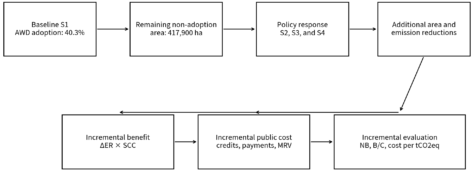
- This study evaluates how carbon credits and direct payments may expand farmer participation in alternate wetting and drying (AWD) and assesses their incremental costs and benefits relative to the existing adoption level. The baseline scenario (S1) sets the national paddy area at 700,000 ha and applies the official 2019 AWD adoption rate of 40.3%. To separate policy-induced participation from the physical mitigation effect of AWD, the same methane reduction rate of 43.23% is applied to all scenarios. S2 applies price-dependent farmer responses from a U.S. Midwest survey, while S3 uses minimum acceptance rates reconstructed from Korean rice farmers’ stated direct-payment preferences. S4 sequentially combines the two responses to avoid double-counting participation. Incremental benefits are calculated only for reductions exceeding S1 and are valued using the Korean social cost of carbon of KRW 45,548 per tCO2eq. Government costs include carbon-credit purchases, direct payments, administration, monitoring, aggregation, and verification. S2 yields benefit-cost ratios of 1.44–1.45, with the active case achieving an additional reduction of 168,631 tCO2eq/yr and a net benefit of KRW 2.374 billion. S3 is cost-effective only at KRW 50,000/ha. S4 achieves the largest additional reduction of 460,395 tCO2eq/yr, but its benefit-cost ratios remain at 0.38–0.75 under full overlapping support. Sensitivity analysis shows that economic feasibility is strongly affected by carbon valuation. The results suggest that carbon credits are a relatively scalable performance-based incentive, while direct payments should be targeted to transition costs, production risks, and areas below the 2030 AWD target. - COLLAPSE
-
Effects of Policy Packages on Farmer Participation and Incremental Cost-Benefit Analysis for Methane Mitigation in Paddy Fields: Carbon Credit and Direct Payment Scenarios
-
Research Article
-
Effects of Regional Weather and Climate Change Scenarios on Solar-Assisted Ventilation Preheating in Weaner Houses
지역 기상과 기후변화 시나리오가 자돈사 태양열–팬코일 환기예열에 미치는 영향
-
Jeonghwa Cho
조정화
- A thermosyphon solar water heater coupled to a fan-coil unit can preheat outdoor ventilation air in weaner houses. Performance from one farm …
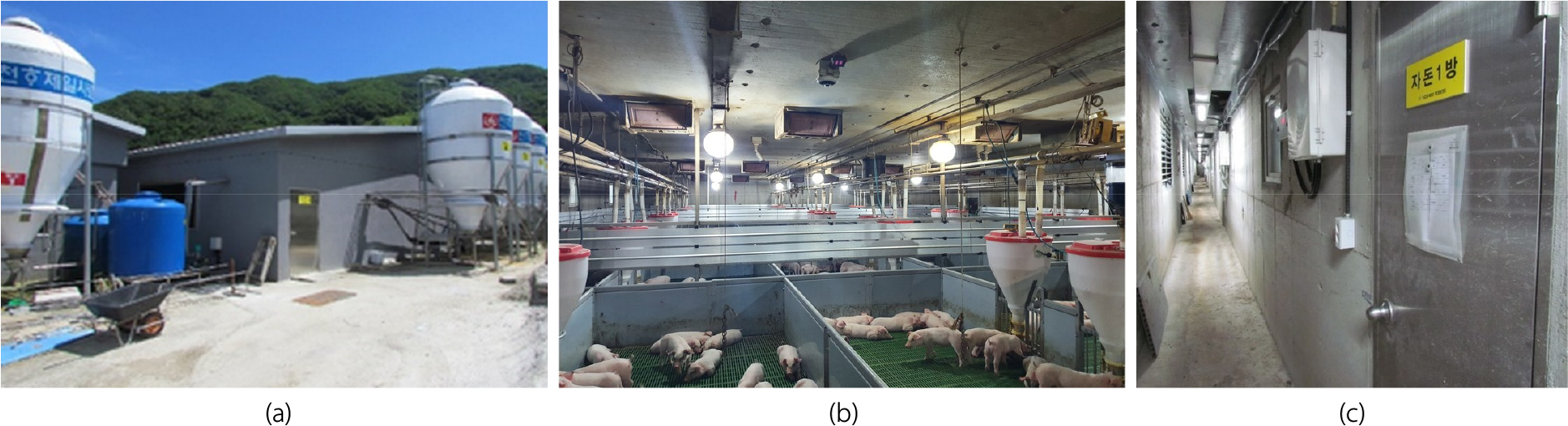
- A thermosyphon solar water heater coupled to a fan-coil unit can preheat outdoor ventilation air in weaner houses. Performance from one farm and one winter month does not show how the same 6 m2 collector and 400 L storage would behave under other Korean regional weather files or climate change scenarios. This study reused a calibrated TRNSYS model of a commercial weaner house and the solar-fan-coil plant, changing only the December weather series and collector slope. Zone air temperatures measured at a mechanically ventilated farm in Suncheon in December 2020 were used to calibrate the house model; the pig-room root-mean-square error was 0.83°C. That comparison is a calibration fit, not an independent validation. Each case ran for 716 h at a 3 min time step with 100% outdoor air. The weather set comprised Suncheon measurements; typical meteorological year files for Suncheon, Iksan, Seosan, Icheon, and Wonju; and +2.2°C and +2.9°C shifts representing mid-century SSP2-4.5 and SSP5-8.5 warming with solar radiation held at measured Suncheon values. The unheated heating load ranged from 149.8 GJ under the SSP5-8.5 shift to 228.2 GJ in Icheon. Absolute heating offset tracked December irradiance more closely than outdoor temperature. The fractional offset was lowest in Iksan, where irradiance was weakest, and rose when warming reduced the load at fixed solar input. Raising collector slope from 33° to 50° changed the 716 h offset only slightly. The plant remains a supplementary preheater; a single national solar fraction is not appropriate. - COLLAPSE
-
Effects of Regional Weather and Climate Change Scenarios on Solar-Assisted Ventilation Preheating in Weaner Houses

Journal Informaiton
 Journal of Korean Society of Agricultural Engineers
Journal of Korean Society of Agricultural Engineers








 The Korean Society of Agricultural Engineers
한국농공학회
(06130) Rm610, Science and Technology Bldg 22, Teheran-ro 7-gil, Gangnam-gu, Seoul, Korea (635-4, Yeoksam-dong)
Tel: +82-02-562-3627 / Fax: +82-02-565-6821 / E-mail: j6348h@hanmail.net Copyright© The Korean Society of Agricultural Engineers. Powered by APUB
Tel: +82-02-562-3627 / Fax: +82-02-565-6821 / E-mail: j6348h@hanmail.net Copyright© The Korean Society of Agricultural Engineers. Powered by APUB